LANDFIRE Fuels
For the most up-to-date information on each LANDFIRE data product, please view the individual product pages on the LANDFIRE Program website.
What you will find in this section
A brief overview of LANDFIRE fuels products
How LANDFIRE creates and updates fuels data
Related LANDFIRE Fuels products
How to download and access LANDFIRE fuels products
What are LANDFIRE Fuels?
Fuels are downstream LANDFIRE products that represent composition and characteristics of live and dead vegetative matter which are of particular importance to the wildland fire community. LANDFIRE provides two separate surface fuel model spatial layers in every delivered version: Anderson 13 (FBFM 13) and Scott and Burgan 40 (FBFM40). In addition, spatial layers representing Forest Canopy Cover, Forest Canopy Height, Forest Canopy Bulk Density and Forest Canopy Base Height are provided. Refer to the links to learn how each of these layers is created. These layers reflect disturbances from the previous fiscal year and are intended to represent typical fuel conditions during a fire season. Users should note that surface and canopy fuels are developed using different processes, although they are consistent with each other.
How are LANDFIRE Fuels data created and updated?
Updating Fuels for Landscape Disturbances
As with all LANDFIRE current time period spatial products, fuels layers are only updated for disturbed pixels. The LANDFIRE version name refers to the latest landscape disturbances that have been included. Prior to LF2023, 10 years of disturbance were updated, e.g., in LF2022 disturbances from 2013 – 2022 were used to update vegetation and fuels.
In LF2023, 20 years of disturbance were included, representing landscape changes from 2004 – 2023 divided into two groups. Pixels disturbed 1 - 10 years prior to 2023 (2014 - 2023) were modified using the usual disturbance rules, while pixels disturbed between 2004 and 2013 (years 11 - 20) were updated using “undisturbed” fuel rules. For LF2023 pixels not identified as disturbed represent conditions in 2016, the most recent prior update. For LF2024, LANDFIRE will revert to updating fuels for 10 years of disturbance.
Reviewing LANDFIRE Fuel Products
LANDFIRE fuels are intended to reflect average fuel conditions in a typical fire season and may need to be adjusted locally to be relevant for a specific fire situation. If recent conditions are atypical (very wet, very dry, excessive wind, etc.) users should expect to adjust the delivered fuels information to reflect those conditions. A guidebook for investigating fuels is available to help users conduct detailed investigations into fuels products. Because canopy fuels and surface fuels are not explicitly linked, adjusting one does not impact the other.
Some key LANDFIRE Fuels products
Seasonal Fuels
Standard LANDFIRE surface fuel products assume a typical weather year and are constant. However, wildland fuels are not necessarily static. They can vary across a year due to weather patterns, excessive rain, drought, etc. LANDFIRE began creating a Seasonal Fuels product that adjusts the most recent Scott and Burgan 40 Fire Behavior Fuel Model (FBFM40) product to reflect drought or seasonable moisture conditions in some areas of the Continental US. This product can improve the accuracy of fire behavior predictions if the local weather has been different from normal. Seasonal fuel products are created for two specific regional fuel situations (1) drought conditions in the Southeast and parts of the Mid-Atlantic (U.S.) and (2) greater than normal abundance of annual herbaceous fuel loading in the Great Basin and Southwest U.S. Note that the name of the Seasonal Fuels product was previously Mod-FIS.
LANDFIRE Total Fuels Change Tool
The LANDFIRE Total Fuels Change Tool (LFTFC) is an ArcPro Add-In developed by LANDFIRE to assign FBFM40 and FBFM13 and canopy fuels to each pixel using rulesets and equations based on input products provided by LANDFIRE. The tool is a part of the LANDFIRE production process but is also available to users for modifying surface and canopy fuels locally. Refer to the LFTFC User Manual for details on how to install and utilize the tool.
Special Fuels Products
Fuel Characterization and Classification System
In alternating years, LANDFIRE produces a spatial layer representing the Fuel Characterization and Classification System. Fuel Characteristic Classification System (FCCS) defines a fuelbed as the inherent physical characteristic of fuel that contributes to fire behavior and effects and can represent a wide variety of scales. In FCCS, fuelbeds represent the structure and composition of wildland fuels and can accommodate a wide range of fuel characteristics in six horizontal fuel layers called strata (Ottmar and others 2007).
Where to find LANDFIRE Fuels data
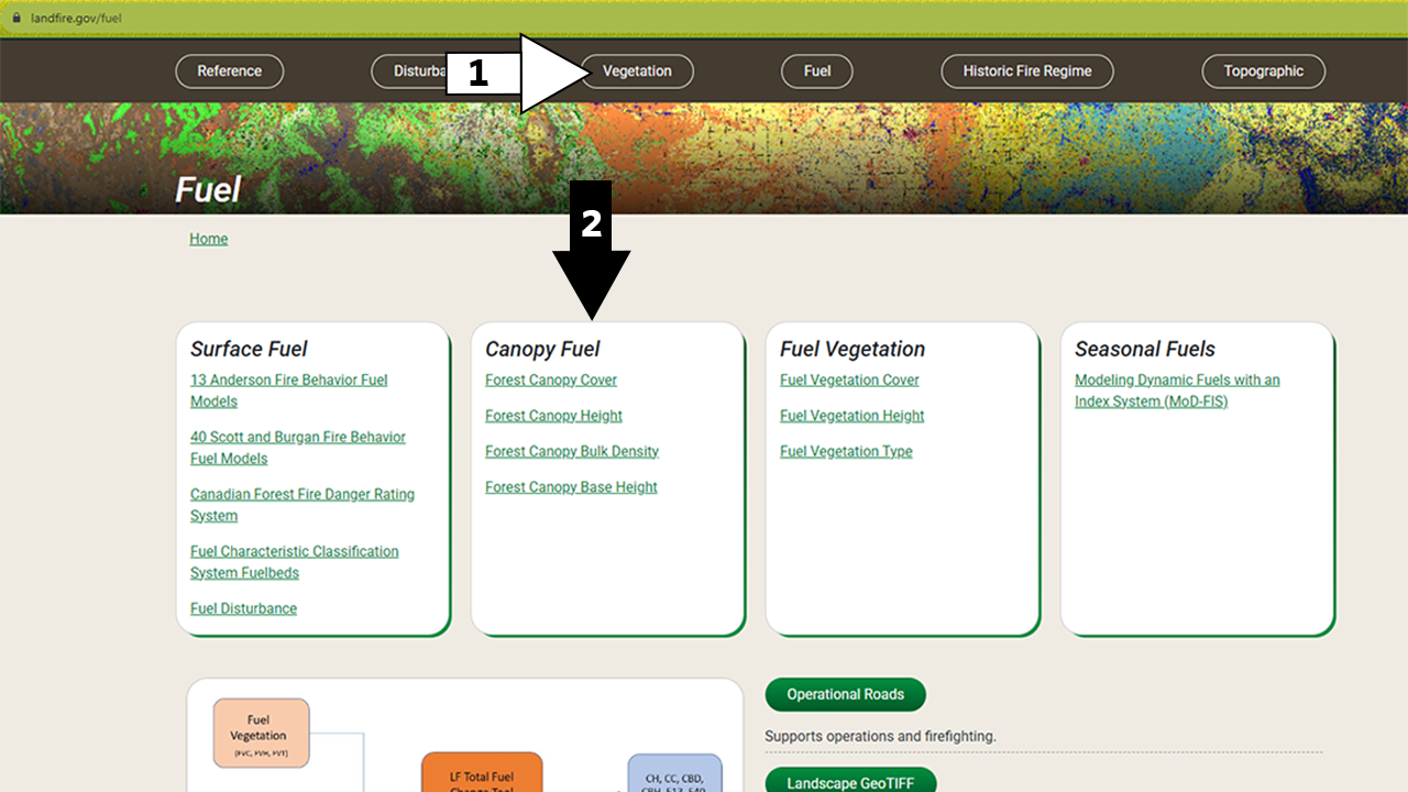
The fuels data products are included in the Fuel section of the LANDFIRE Program Website. You can access this from the buttons across the top of the page (#1 in the screenshot below).
Here you will find general information about some of the products mentioned above. The page also includes links to all fuel products delivered by LANDFIRE (#2 in the screenshot below). Each fuels-specific product page has more information on that fuels product along with links to download the fuel product - via the LANDFIRE Map Viewer, full extent downloads, and a variety of ways to stream data into your maps. The page also includes resources such as attribute tables, metadata, and supplemental information.
In a later section of this site, you will learn more about the differences between these download methods and how to access data via each method.
Screenshots of Data Access and Resources on the Fuels page
Common mistakes with fuels data
Not adjusting the data to your local conditions
LANDFIRE Fuels products serve as a foundational resource, providing analysts with essential raster data for input into fire modeling software. These products require adjustments tailored to the specific year and local conditions of the area being modeled. Some analysts expect fuels products to operate ‘out-of-the-box,’ which can lead to the perception that LF fuels products are not accurate. Before dismissing these products as inaccurate, we recommend that users try fine-tuning your raster details to better align with local conditions.
Thinking Fuel Vegetation Cover (FVC) and Height (FVH) are current fuels
A frequent misconception is that FVH and FVC represent current fuel conditions. These layers reflect pre-disturbance vegetation structure and are intended as inputs to the LFTFC, which models post-disturbance fuels and outputs layers such as Forest Canopy Cover, Forest Canopy Height, Canopy Bulk Density, Canopy Base Height, FBFM40, and FBFM13. Misinterpreting these inputs as final fuels data can lead to inaccurate assessments. To ensure reliable outputs, users should follow the full modeling workflow and apply the LFTFC tool appropriately to derive current, scenario-specific fuels layers.
Helpful Resources
Seasonal Fuels (MoD-FIS)
LANDFIRE Total Fuels Change Tool (LFTFC)
Wildfire Risk to Communities uses LANDFIRE fuels to provide a free, easy-to-use website with interactive maps, charts, and resources to help communities understand, explore, and reduce wildfire risk
The Modifying LANDFIRE Geospatial Data for Local Applications pdf guide
LANDFIRE Office Hour: Acquiring and using LANDFIRE fuels data in geospatial modeling applications (opens a YouTube video)
Still have questions? LANDFIRE is here to help.
Ask the LANDFIRE Helpdesk (email link).
Search and subscribe to the LANDFIRE YouTube Channel (see tutorials, Office Hours, quick demonstrations).
Join an Office Hour (monthly meeting with open format Q & A with LANDFIRE experts).
Schedule a meeting (email link) with TNC’s LANDFIRE Team.