The Reference Conditions Table
For the most up-to-date information on each LANDFIRE data product, please view the individual product pages on the LANDFIRE Program website.
What you will find in this section
The Reference Conditions Table (RCT) is an output from the Biophysical Settings Models that focuses specifically on succession class and fire regime. In this section we will:
Explore the fields in the Reference Conditions Table
Understand how the Reference Conditions Table is linked to the BpS through succession class
Discuss Reference Conditions Table use cases
Explain where to get the Reference Conditions Table
The Reference Conditions Table
💡 We suggest you review the content on Biophysical Settings, specifically the Biophysical Settings Spatial Data page where we discuss BpS attributes, before you work through this material. We discuss Succession Class in more detail in a later section of this website. Remember that reference conditions relate to the pre-European colonization period and not today or the future.
The Reference Conditions Table summarizes the vegetation and fire regime reference conditions for every BpS. Vegetation reference conditions estimate the relative proportion of each succession class. Fire regime reference conditions estimate the frequency and severity of fire within a BpS. LANDFIRE calculates reference conditions using the BpS model. These results are also in the BpS description.
When you download the Reference Condition Table you will get a zipped .csv file with the following fields:
Biophysical Settings identifiers:
- BpS_Code
- BpS_Name
- Model_Code
Succession Class Reference Percents, Classes A – E, e.g., ‘ClassA_ReferencePercent’
Fire Return Intervals, surface, mixed, and replacement, e.g., ‘FRI_ReplacementFire’
Percent of fires, surface, mixed, and replacement, e.g., ‘PercentOfFires_ReplacementFire’
Fire Regime Group: FRG_New. Fire regime group is classified based on the fire frequency and severity as shown in the table below.
| Fire Regime Group | All Fire Fire Return Interval | % Replacement Fire |
|---|---|---|
| I-A | 0 - 5 years | Less than 66.7% |
| I-B | 6 - 15 years | Less than 66.7% |
| I-C | 16 - 35 years | Less than 66.7% |
| II-A | 0 - 5 years | 66.7% or greater |
| II-B | 6 - 15 years | 66.7% or greater |
| II-C | 16 - 35 years | 66.7% or greater |
| III-A | 36 - 100 years | Less than 80% |
| III-B | 101 - 200 years | Less than 66.7% |
| IV-A | 36 - 100 years | 80% or greater |
| IV-B | 101 - 200 years | 66.7% or greater |
| V-A | 201 - 500 years | Any severity |
| V-B | 501+ years | Any severity |
You can link the BpS Reference Condition Table to the BpS Description document using the BpS code. The class letters are defined in the Succession Classes Description section of the document.
Some common uses of the Reference Conditions Table
This table can be a quick way to get reference percentages and to understand overall historical fire dynamics of BpS. LANDFIRE Uses the RCT to compare reference succession class amounts to current amounts to calculate vegetation departure.
Other common uses of the RCT include:
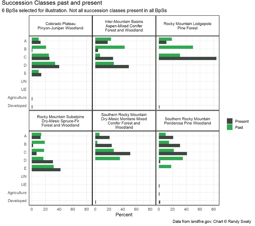
Getting reference succession class percentages when making charts such as the demo figure below. This figure depicts reference vs. current succession classes for the Southern Rockies ecoregion and could be helpful when thinking about the major Biophysical Settings on a landscape and how their succession classes may (or may not) have changed over time.
Understanding the relative proportion of surface, mixed, and replacement fire severity for a given BpS.
Comparing fire frequency, severity, and fire regime between BpS.
Quickly calculating estimated historical annual surface acres burned:
Quantify the amount of a BpS on the landscape: Let ( A ) represent the acres of the landscape. For example, ( A = 200,000 ) acres.
Quantify the return interval: Let ( R ) be the return interval for surface fires. For this example, ( R = 25 ), so the annual probability ( P ) is given by: P = 1/R = 1/25 = 0.04
Calculate the Area Affected by Surface Fire: You multiply the acres on the landscape by the return interval. The area affected ( S ) can be calculated as: S=A×P
Putting it all together, the equation becomes:
S=200,000×(0.04)=8,000 acres of surface fire
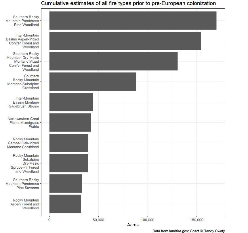
The following chart depicts annual acres burned, all fire types, for the most dominant BpSs of the Southern Rockies, calculated using the formula above but including all fire types. Explore the context for this chart.
The reference conditions table is important in landscape assessments and LANDFIRE’s vegetation departure, both of which we will discuss more in-depth in future sections of this learning website.
Where to find the Reference Conditions Table
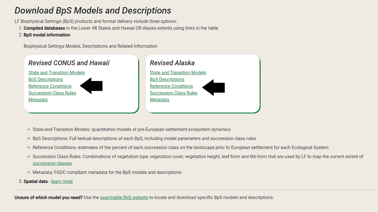
The RCT is downloadable on the Bps Models page of the LANDFIRE Program website. Scroll down to the Download BpS Models and Descriptions section, then click Reference Conditions which will begin an immediate download. Unless you specify the download location, the file will likely end up in your default Downloads folder.
To access the file, open the .csv in Excel, R, or any other program you use to view .csv files.
Helpful Resources
The Reference Condition Table (downloads a zip file)
Succession Class mapping rules spreadsheet (downloads a zip file)
SClass Readme file (opens a pdf)
Still have questions? LANDFIRE is here to help.
Ask the LANDFIRE Helpdesk (email link).
Search and subscribe to the LANDFIRE YouTube Channel (see tutorials, Office Hours, quick demonstrations).
Join an Office Hour (monthly meeting with open format Q & A with LANDFIRE experts).
Schedule a meeting (email link) with TNC’s LANDFIRE Team.