Biophysical Settings Spatial Data
For the most up-to-date information on each LANDFIRE data product, please view the individual product pages on the LANDFIRE Program website.
What you will find in this section
An overview of the Biophysical Settings spatial data
Key attributes of the Biophysical Settings spatial data
Where to find Biophysical Settings data on the LANDFIRE Program website
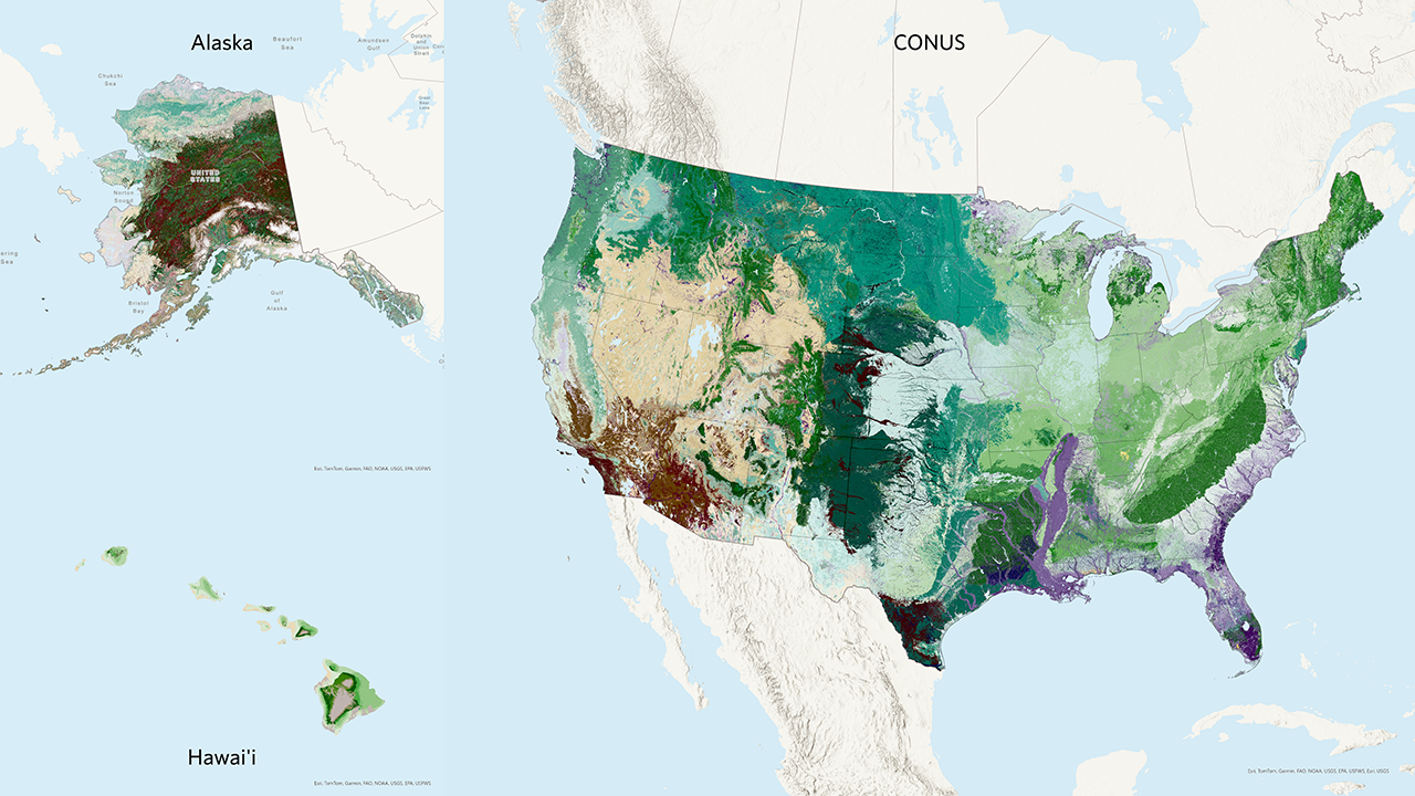
About Biophysical Settings spatial products
LANDFIRE’s Biophysical Settings spatial product, also known as BPS, is a spatial representation of the BPS concept we discussed in the previous section. LANDFIRE uses BPS to depict reference conditions of vegetation across landscapes. Each BPS is described in a BPS Description document. This includes information about dominant and indicator species, site characteristics, and natural disturbance regimes. To understand how the map was created, please refer to Rollins et al. 2009 (opens a pdf).
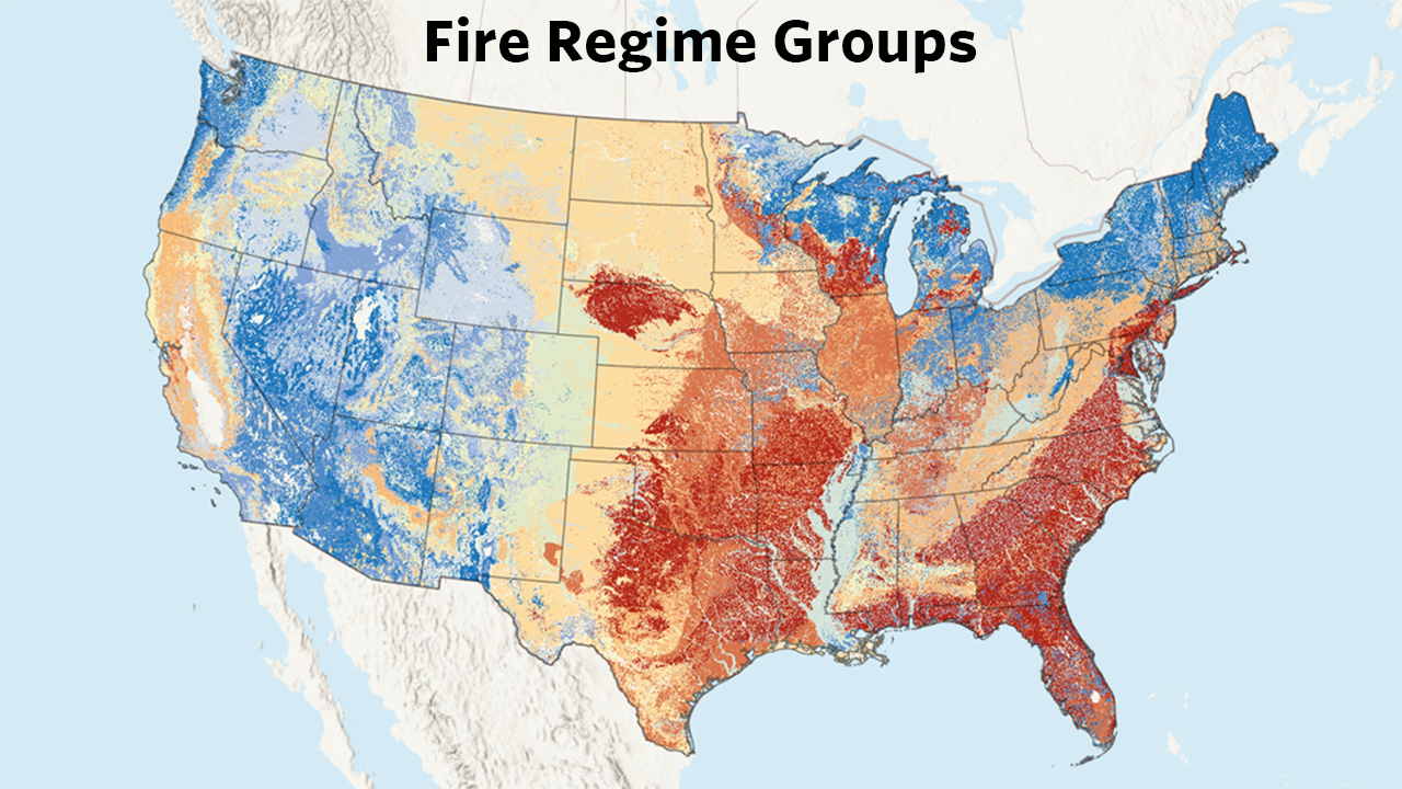
Beginning with LF2016, Historic Fire Regime information (pre-European colonization fire return intervals, percent of fire severities, and fire regime groups) were delivered by LANDFIRE as attributes of the BPS spatial layer instead of as separate spatial layers. Since LANDFIRE’s fire regime information is based on the historical context, we included it with BPS to provide a better picture of the pre-colonization landscape. However, in version LF2023 and beyond LANDFIRE will again deliver pre-European colonization information as three separate spatial layers along with the fully attributed BPS spatial layer. These layers are pre-European colonization Fire Regime Group, Fire Return Intervals (for Low, Moderate and Replacement severities) and Percent Fire Severity (for Low, Moderate and Replacement fires).
The Biophysical Settings attributes correspond with the information in the Biophysical Settings Descriptions discussed in the BPS Documents section of this website. We suggest that you review this information for a more complete understanding of the Biophysical Settings attributes.
For even more context, we’ve created this short BPS 101 video on YouTube (3 minutes ).
Key BPS Attributes include
BPS_CODE: The unique code LANDFIRE uses for each Biophysical Setting.
Zone: The NLCD map zone(s) the BPS is located in or relates to.
BPS_MODEL: The unique BPS Model code. This combines the BPS code with the zone(s) the model is located in. In some cases, a BPS with the same name and BPS Code may be split among map zones because the vegetation or disturbance regimes vary enough that the descriptions differ. An example of this is the ‘Laurentian-Acadian Northern Hardwoods forest’ BPS (13020), which has four different BPS Models:
- 13020_40 (BPS 13020, Map Zone 40)
- 13020_63 (BPS 13020, Map Zone 63)
- 13020_65_66 (BPS 13020, Map Zone 65 and 66)
- 13020_65_66 (BPS 13020, Map Zone 65 and 66)
Note, there will be a separate row and VALUE for each BPS_CODE/MapZone combination, such as presented in the above example where there are two rows for 13020_65_66.
The attribute for map zone in the BPS attribute table creates duplicate rows in the table in cases where one model applies to multiple map zones. For users only interested in unique BPS, we recommend performing a spatial lookup based on the BPS_Model code. This will allow the user to visualize each unique BPS in an area of interest.
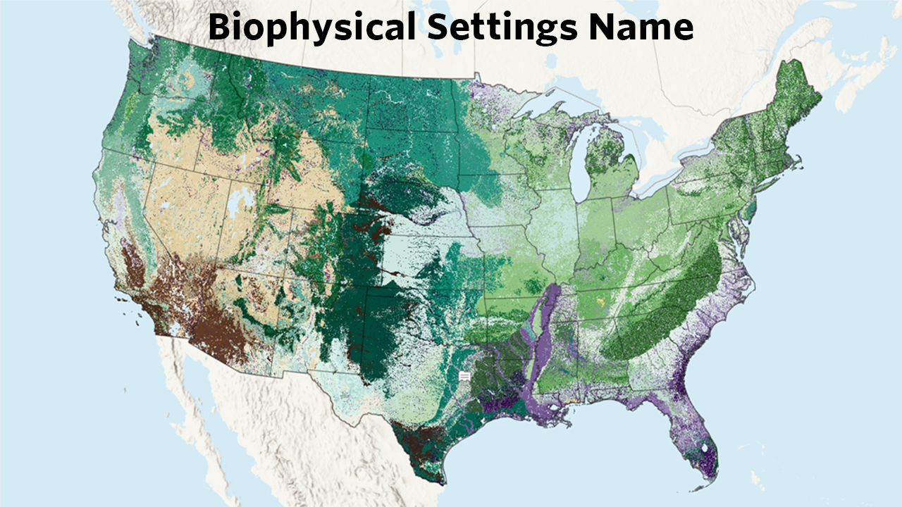
BPS_NAME: The name of the Biophysical Setting.
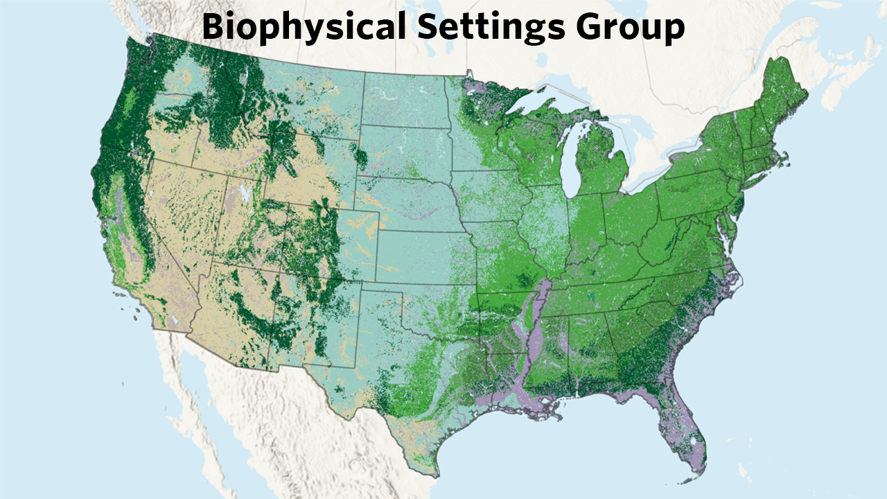
GROUPVEG: Coarse vegetation type groupings highlighting the high-level dominant vegetation within that BPS. Note that if a BPS is listed as ‘Hardwood’ it may actually be a mix of hardwood, herbaceous, savannah, and more, but hardwoods are defined as the dominant vegetation type
Pre-European Colonization Fire Regime Attributes:
- FRI_REPLAC: Average historic replacement-severity fire frequency for the BPS.
- FRI_MIXED: Average historic mixed-severity fire frequency for the BPS.
- FRI_SURFAC: Average historic surface-severity fire frequency for the BPS.
- FRI_ALLFIR: Average historic fire frequency for all fires within the BPS.
- PRC_REPLAC: Percent of historic fires with replacement severity for the BPS.
- PRC_MIXED: Percent of historic fires with mixed severity for the BPS.
- PRC_SURFAC: Percent of historic fires with surface severity for the BPS.
- FRG_NEW: The fire regime group for the BPS. Fire regime groups are based on a combination of fire return interval and fire severity. The current Fire Regime Groups were updated in 2016 and have been modified from a previous classification. You can find the new breakdown of fire regime groups in the Attribute Data Dictionary (opens a pdf) for the BPS spatial data.
The LANDFIRE spatial data layers allow for display and analysis on multiple attributes and at varying levels of specificity. Three examples of how you can display, aggregate, and evaluate Biophysical Settings information are presented in the following images.
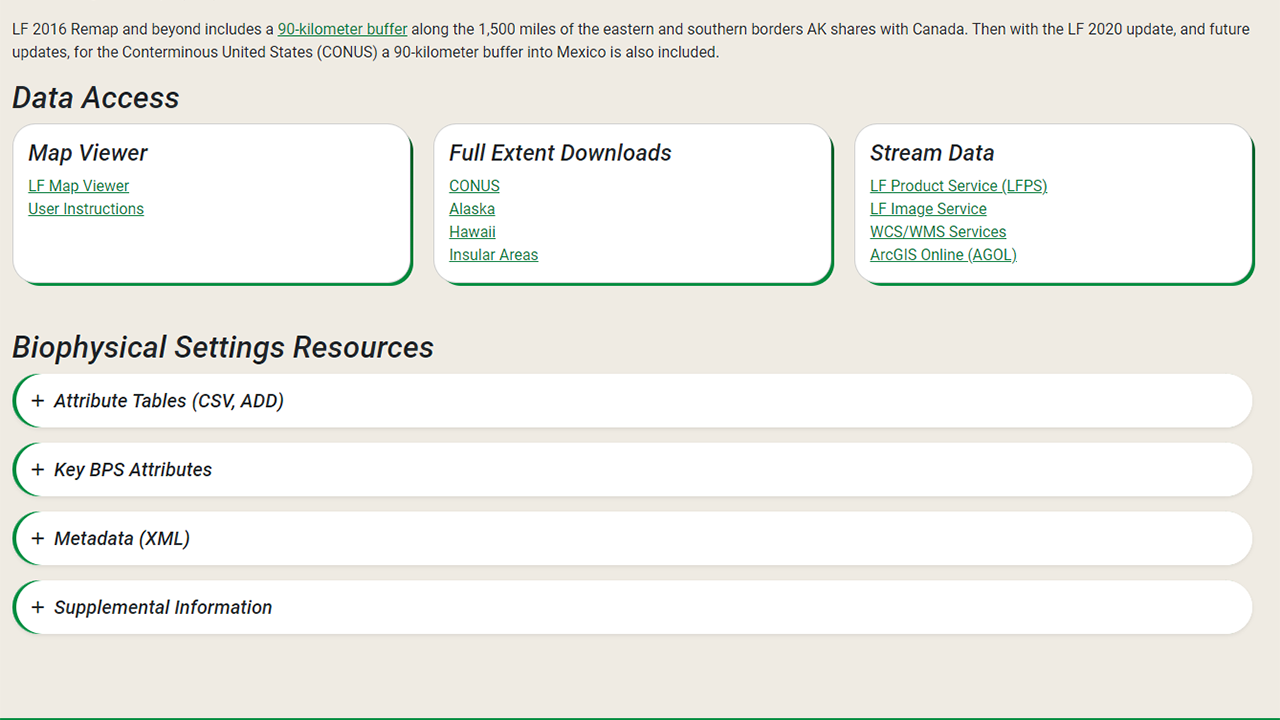
Where to find BPS data
💡 Screenshots of the process are included below the written instructions for those who find them useful.
The Biophysical Settings data is included in the Vegetation section of the LANDFIRE Program Website on the Biophysical Settings page. Here you will find an overview, including the information above along with further details and links to other important documents. Perhaps of most interest are the download links - via the LANDFIRE Map Viewer, full extent downloads, and a variety of ways to stream data into your maps. The page also includes resources such as attribute tables, metadata, and supplemental information.
In a later section of this site, you will learn more about the differences between these download methods and how to access data via each method.
Pro tip: We recommend using the most recent BPS data for the conterminous US (CONUS), AK, and HI. For CONUS, the latest version is LF2020; for AK the latest version is LF2023; for HI the latest version is LF2016. If you are already using previous versions, please be aware of some important changes including:
The mapping of rock, sparse, barren, and water has changed over time to remain consistent with these types in other LANDFIRE products.
The BPS legend did change in Alaska. In collaboration with NatureServe LANDFIRE instituted major changes to the BPS legend in AK in LF2024 and later products.
After the BPS description and model review in 2015, there were some important changes such as the addition of some BPS for LF2016 (e.g., Northern Pine-Oak (Pine Dominated), and changes to the FRG information for several BPS.
Helpful Resources
Short BPS 101 video on YouTube (3 minutes )
Still have questions? LANDFIRE is here to help.
Ask the LANDFIRE Helpdesk (email link).
Search and subscribe to the LANDFIRE YouTube Channel (see tutorials, Office Hours, quick demonstrations).
Join an Office Hour (monthly meeting with open format Q & A with LANDFIRE experts).
Schedule a meeting (email link) with TNC’s LANDFIRE Team.